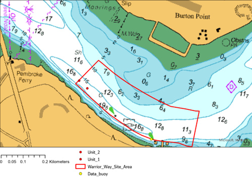
Deployment of tidal monitoring equipment at META Warrior Way Site between 28th of October 2026 and 28th of January 2027.
- MARINERS ARE HEREBY ADVISED that, two tidal monitoring units will be deployed on the seabed at the META Warrior Way site in approximate position 51° 42.21'N 4° 55.67'W between 28th of October 2026 and 28th of January 2027.
- When deployed the units will stand 1.2m above the seabed and will not be marked by a surface marker buoy. (See below chart).
- A data buoy will also be deployed in approximate position 51° 42.08'N 4° 55.36'W. (see chartlet). The data buoy will be yellow, displaying a St Andrew’s Cross and light FL Y 4s.
- Mariners are advised not to anchor in proximity to any deployed equipment in the area.
- Admiralty charts 3275 and IMRAY Y26 and 2600 atlas refer.
- For details and updates on operations contact Milford Haven VTS on VHF Ch12 or vts@mhpa.co.uk.
- This notice will self-cancel at 23:59hrs on Saturday the 30th of January 2027.