From 9 September 2026, a tidal current study will take place within the Milford Haven Waterway for approximately six weeks.
-
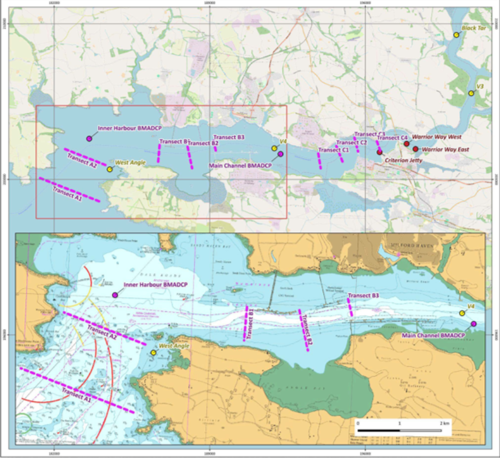
MARINERS ARE HEREBY ADVISED that, From Wednesday 9 September 2026, for a period of approximately six weeks, a tidal current study will be undertaken within the Milford Haven Waterway. As part of the study, two seabed-mounted Acoustic Doppler Current Profilers (BM-ADCPs) will be deployed at the following locations (as shown on chartlet):
Location A – Dale Roads 51° 42.0242′ N, 005° 08.0023′ W
Location B – Pwllcrochan (No. 5A Buoy and Outfall Buoy) 51° 41.8430′ N, 005° 00.5283′ W.
- Each BM-ADCP deployment location will be marked on the surface by a yellow special mark buoy, fitted with a special mark topmark and exhibiting a flashing yellow light: Fl(5) Y 20s.
- In addition, the survey vessel ‘Shoreline’ will undertake vessel-mounted ADCP surveys along a series of predetermined transects at three locations within the Waterway. Survey operations will be undertaken over complete tidal cycles, with the vessel repeatedly transiting the survey lines at approximately 3–5 knots. (See below chartlet).
- Mariners are requested to keep well clear of the deployed equipment and associated marker buoys and to navigate with caution when passing the survey locations.
- A further Notice will be issued when works have been completed.
- Admiralty Chart 3275 and IMRAY Y26 and 2600 Atlas refer.
Study area overview with transects and ADCP locations.